What Are Ground Control Points and Why Do They Matter in Aerial Mapping?
- Adam
- Nov 26, 2025
- 5 min read
Aerial mapping has changed dramatically over the past few years, thanks to the rise of drones, photogrammetry software, and advanced surveying techniques. But even with powerful tools, one element still plays a key role in achieving accuracy: Ground Control Points (GCPs). If you’re working in surveying, construction, agriculture, land planning, or environmental monitoring, understanding how GCPs work can make a big difference in your mapping results.
In this article, we’ll break down what ground control points are, why they matter, how they are used in drone mapping, and whether newer technologies like RTK and PPK could replace them in the future.
What Are Ground Control Points?
Ground Control Points are accurately surveyed reference markers placed on the ground before conducting an aerial survey. These points have known real-world coordinates (usually measured with GNSS or RTK equipment) and are later used in mapping software to align aerial images with their exact locations on Earth.
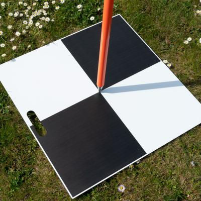
Some GCPs are temporary markers, such as checkerboard panels or painted symbols on the ground. Others may already exist as permanent structures, such as survey monuments, pillars, or concrete benchmarks.
How GCPs Are Used
Once a drone or UAV captures aerial images, the mapping software searches for GCP markers in each image. These references allow the software to georeference the entire map so it aligns correctly with real-world coordinates. The more precise the control points, the more accurate the final 2D or 3D model will be.
Why Are Ground Control Points Important?
Even high-quality drone footage isn’t enough to guarantee accuracy. Without proper control on the ground, your aerial map might look correct but could easily be off by a few meters. In fields like construction, land surveying, mining, or infrastructure planning, such errors can lead to real-world problems and costly decisions.

Here’s why GCPs are valuable:
1. Improved Position Accuracy
GCPs ensure that orthomosaics and 3D models match real-world coordinates. This is essential when working with GIS platforms, CAD files, or topographic maps.
2. Consistent Survey Results
Having anchor points throughout the survey area helps create uniform and reliable data, especially when stitching together high-resolution images.
3. Legal and Compliance Requirements
Many government agencies and contractors require the use of GCPs for official land surveys or aerial inspections to meet accuracy standards.
4. Better Scaling & Height Measurement
In terrain modelling, control points help define elevation changes, making your digital surface model (DSM) or digital terrain model (DTM) more trustworthy.
How Many GCPs Are Needed for a Survey?
The number of ground control points depends on the size and complexity of the survey area. While there’s no universal rule, professionals generally follow this guideline:
Survey Area Size | Recommended GCPs |
Under 5 acres | 4–5 control points |
5–20 acres | 5–10 control points |
20+ acres | Spread evenly across boundaries |
Complex terrain or high accuracy needed | Add more GCPs |
Place GCPs at the corners of the area and at least one in the center. If the land has slopes, hills, or obstacles, using additional points will help improve elevation accuracy.
GCPs vs RTK and PPK: Do We Still Need Them?
Many drone pilots now use RTK (Real-Time Kinematic) or PPK (Post-Processed Kinematic) technology, which provides highly accurate GPS positioning with fewer ground control markers. So, does this mean GCPs are becoming outdated?
Not quite.
When GCPs Are Still Necessary:
When ultra-high accuracy is required (sub-centimetre precision)
In areas with weak GNSS signals
For government/contractual surveying standards
When mapping rough, uneven, or obstructed terrain
When RTK/PPK Is Enough:
Large-scale surveys with moderate accuracy are needed
Quick mapping tasks with time limitations
Where placing GCPs is difficult or unsafe
In reality, many professionals use a hybrid approach, combining RTK drones with a few key control points to achieve maximum confidence.
Best Practices for Using Ground Control Points
To achieve accurate aerial mapping, GCP placement and measurements must be carefully performed. Here are some useful tips:
Choose Visible Markers
Use high-contrast designs (checkerboard or “X” shapes) so they’re easily detectable in drone images.
Measure with GNSS/RTK Equipment
GCPs must have precisely measured coordinates. Consumer GPS devices are usually inaccurate.
Spread Them Evenly
Place control points around the edges and one or more in the center.
Avoid Shadows or Obstruction
Place them in open areas away from trees, traffic, and harsh shadows that make detection harder.
Record and Label Each Point
Add numbers and documentation so you can match them correctly during processing.
Are Ground Control Points Worth the Effort?
Yes, especially when accuracy truly matters. While placing GCPs takes time and planning, the benefits often outweigh the effort. Aerial maps without georeferenced control points can appear visually correct but may lead to costly errors in real-world applications.
Whether you're working in construction, land surveying, agriculture, flood mapping, or urban planning, a few well-placed GCPs can be the difference between a rough estimate and a reliable survey.
Frequently Asked Questions (FAQs)
1. What are Ground Control Points (GCPs)?
Ground Control Points are accurately surveyed markers placed on the ground to help align drone images with real-world coordinates during aerial mapping.
2. Why are GCPs important in drone surveying?
GCPs improve the accuracy of maps and 3D models by providing reference coordinates that mapping software uses to correctly position survey data.
3. How many GCPs do I need for a drone survey?
The number depends on the survey area. Small sites may need 4–5 points, while larger or complex areas may require 10 or more for accurate results.
4. Can RTK or PPK drones replace GCPs?
RTK and PPK drones reduce the need for many control points, but GCPs are still recommended when high precision or legal standards are required.
5. What equipment is used to measure GCPs?
Surveyors typically use RTK GNSS or high-precision GPS equipment to record the exact coordinates of each control point.
6. How do I make GCPs visible to drones?
Use high-contrast markers, checkerboard patterns, or painted symbols placed in open, shadow-free areas on the ground.
7. Are GCPs necessary for 3D modeling?
Yes, especially when elevation accuracy is important. GCPs help create reliable Digital Terrain Models (DTMs) and Digital Surface Models (DSMs).
8. Can I reuse GCPs for future surveys?
If they’re permanent markers with stable coordinates, they can be used again. Temporary GCPs may need to be remeasured each time.
Final Thoughts
Ground Control Points are still one of the most reliable ways to achieve precise aerial mapping results. Even with advanced drone technologies such as RTK and PPK, GCPs remain valuable for validating accuracy and building trust in survey data. As mapping technology continues to evolve, these control markers will likely become smarter, easier to deploy, and better integrated into automated workflows.
If you're planning a drone survey soon, take a moment to consider your control strategy because accuracy starts from the ground up.


Comments