What Are Ground Control Points in Aerial Mapping?
- Adam
- Jan 27
- 4 min read
Aerial mapping has changed how professionals measure land, plan construction projects, and analyze terrain. Drones can capture thousands of images in a short time, but images alone do not guarantee accurate results. To convert aerial data into precise maps, surveyors rely on Ground Control Points.
Ground Control Points (GCPs) connect aerial imagery to real-world coordinates. They help ensure that measurements, distances, and elevations in a map match actual ground conditions. Without them, even high-quality drone images can contain positional errors that affect decision-making.
Understanding how Ground Control Points work is essential for anyone involved in aerial mapping.
Understanding Ground Control Points
Ground Control Points are clearly marked locations placed on the ground before or during a drone survey. Surveyors measure these points using high-accuracy GPS or GNSS equipment. Each point receives exact coordinate values for latitude, longitude, and elevation.
When a drone captures aerial images, the mapping software identifies these known points within the photos. The software then aligns the entire dataset using these fixed references. This process allows aerial imagery to be matched to real-world positions rather than estimated locations.
In simple terms, Ground Control Points act as anchors that hold the aerial map in the correct place.
Why Aerial Mapping Needs Ground Control Points
Drones rely on onboard GPS systems to record image locations. While this GPS data is helpful, it often contains small inaccuracies. These errors may seem minor, but they can grow across large survey areas.
Several factors can affect drone positioning accuracy:
Satellite signal drift
Camera angle changes during flight
Terrain elevation variation
Environmental interference
When these issues combine, the final map may shift horizontally or vertically. Ground Control Points correct these inconsistencies by providing trusted reference locations.
By comparing drone-derived positions with known GCP coordinates, the software adjusts the model to reflect true ground conditions.
How Ground Control Points Improve Accuracy
Ground Control Points significantly enhance both horizontal and vertical accuracy in aerial mapping.
During data processing, the software checks where each GCP appears in multiple images. It then compares those positions with the surveyed coordinates. This comparison allows the system to correct distortions, scale errors, and elevation mismatches.
As a result, the final outputs show improved:
Map alignment
Elevation accuracy
Distance measurements
Surface models
This level of precision is especially important for professional, regulated projects, where even small errors can lead to costly mistakes.

Common Types of Ground Control Points
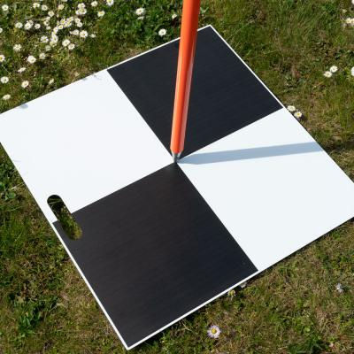
Ground Control Points must be easily recognizable in aerial imagery. Surveyors typically use high-contrast targets that stand out clearly from the surrounding surface.
Common GCP types include:
Black and white checkerboard targets
Diagonal two-tone square panels
Painted ground markers
Temporary fabric or plastic targets
These targets remain visible under different lighting conditions and from various flight heights. Their simple geometric shapes enable software to quickly identify them during processing.
Proper Placement of Ground Control Points
Correct placement plays a major role in the accuracy of aerial mapping. Random positioning can limit the effectiveness of even well-measured GCPs.
Surveyors usually place Ground Control Points:
Across the entire survey area
Near corners and boundaries
In open, flat locations
Away from shadows, trees, or tall objects
Distributing GCPs evenly helps maintain consistent accuracy throughout the map. Using too few points or clustering them into a single area can reduce reliability.
Good placement ensures the entire dataset benefits from accurate reference information.
Using Ground Control Points During Processing
After the drone flight, surveyors import the measured GCP coordinates into photogrammetry software. The software then displays these points on the images.
The operator manually marks each GCP in multiple photos. This step allows the system to understand how the ground references appear from different angles.
Once marked, the software recalculates camera positions and model geometry. This refinement process improves alignment and strengthens the overall accuracy of the map.
Taking time during this stage leads to higher-quality final outputs.
Verifying Accuracy with Ground Control Points
Ground Control Points also support quality control. After processing, the software generates error reports that show how closely the model matches the known coordinates.
Surveyors review:
Horizontal error values
Vertical error values
Reprojection accuracy
Consistency between points
If errors exceed acceptable limits, adjustments can be made before final delivery. This verification step builds confidence in the results and reduces the risk of rework.
When Ground Control Points Are Most Important
Some small projects may rely solely on drone GPS data. However, many professional applications require GCPs to meet accuracy standards.
Ground Control Points are essential for:
Construction planning
Engineering design
Volume calculations
Land development surveys
Infrastructure mapping
In these projects, accuracy directly affects safety, budgets, and timelines. GCPs help ensure aerial mapping data supports reliable decision-making.
Final Thoughts
Ground Control Points form the foundation of accurate aerial mapping. They connect drone imagery to real-world coordinates and correct the small positioning errors that naturally occur during flight.
By placing visible targets, measuring precise coordinates, and carefully processing the data, surveyors can produce maps that reflect actual ground conditions. This process improves alignment, strengthens accuracy, and increases confidence in the final results.
Aerial mapping becomes truly reliable only when supported by well-planned Ground Control Points.
FAQs
What are Ground Control Points in aerial mapping?
Ground Control Points are known reference locations measured with high-accuracy GPS or GNSS equipment. They help align aerial images with real-world coordinates and improve overall mapping accuracy.
Why are Ground Control Points important for drone mapping?
Ground Control Points correct positional errors from drone GPS data. They improve horizontal and vertical accuracy, ensuring measurements, elevations, and distances reflect actual ground conditions.
How many Ground Control Points are needed for aerial mapping?
The number depends on the size and complexity of the area. Most projects require at least five well-distributed points, with larger or uneven terrain needing additional GCPs for consistent accuracy.
Can aerial mapping be done without Ground Control Points?
Yes, but accuracy may decrease. Projects that require professional-level precision usually depend on Ground Control Points to meet quality and regulatory standards.


Comments