Understanding Ground Control Points for Accurate Mapping
- Adam
- Sep 1, 2025
- 5 min read
Updated: Sep 3, 2025
Mapping has become an essential part of various industries, from construction to environmental studies. One of the key elements that ensure the accuracy of maps is the use of Ground Control Points (GCPs). These points serve as reference markers that help in aligning and calibrating data collected from aerial surveys or satellite imagery. In this post, we will explore what GCPs are, why they are important, and how to effectively use them for accurate mapping.
What are Ground Control Points?
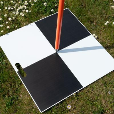
Ground Control Points are specific locations on the Earth's surface with known geographic coordinates. These coordinates are established through precise surveying techniques. GCPs are used to improve the accuracy of geospatial data collected from various sources, such as drones, satellites, or traditional surveying methods.
GCPs can be marked using physical markers, such as flags or painted spots, or they can be identified using GPS devices. The key is that their exact location is known, which allows for better alignment of the data collected during mapping.
Why are GCPs Important?
The importance of Ground Control Points cannot be overstated. Here are some reasons why they are crucial for accurate mapping:
Accuracy: GCPs help in correcting any distortions in the data collected. Without them, the resulting maps may have significant errors.
Calibration: They allow for the calibration of aerial imagery, ensuring that the images align correctly with the real-world coordinates.
Validation: GCPs serve as a means to validate the accuracy of the mapping process. By comparing the collected data with the known coordinates of GCPs, one can assess the quality of the mapping.
Consistency: Using GCPs ensures that different datasets can be compared and integrated effectively, leading to more reliable results.
Efficiency: By establishing GCPs before data collection, the mapping process can be streamlined, saving time and resources.
How to Select Ground Control Points
Choosing the right GCPs is essential for effective mapping. Here are some tips for selecting appropriate points:
Visibility: Choose points that are easily visible from the air. This can include large, flat areas or distinct landmarks.
Distribution: Ensure that GCPs are evenly distributed across the area being mapped. This helps in reducing errors and improving overall accuracy.
Stability: Select locations that are stable and unlikely to change over time. Avoid areas that may be affected by construction or natural events.
Accessibility: Make sure that the GCPs can be easily accessed for verification and data collection.
Collecting Data from GCPs
Once you have selected your GCPs, the next step is to collect data from them. Here are some methods to do this:
GPS Surveying: Use high-precision GPS equipment to measure the exact coordinates of each GCP. This method provides the most accurate results.
Total Station: A total station can be used for precise measurements, especially in areas where GPS signals may be weak.
Photogrammetry: This method involves taking overlapping photographs of the GCPs from different angles. Software can then be used to extract the coordinates from these images.
Drones: Drones equipped with GPS can also be used to capture data from GCPs, making the process faster and more efficient.
Integrating GCPs into Mapping Projects
After collecting data from your GCPs, the next step is to integrate this information into your mapping project. Here’s how to do it:
Data Processing: Use GIS (Geographic Information System) software to process the data collected from GCPs. This software can help in correcting any distortions in the mapping data.
Georeferencing: Align the collected data with the known coordinates of the GCPs. This process is known as georeferencing and is crucial for ensuring accuracy.
Quality Control: After integrating the GCPs, conduct a quality control check. Compare the mapped data with the known coordinates to identify any discrepancies.
Final Adjustments: Make any necessary adjustments to improve the accuracy of the final map. This may involve reprocessing the data or adding additional GCPs if needed.
Case Study: Using GCPs in Urban Planning
To illustrate the importance of GCPs, let’s look at a case study in urban planning. A city planning department was tasked with creating a new zoning map. They decided to use aerial imagery combined with GCPs to ensure accuracy.
The team selected several GCPs throughout the city, focusing on easily identifiable landmarks such as parks and large buildings. They used high-precision GPS equipment to collect data from these points.
After processing the data, the team found that the initial aerial imagery had some distortions. However, by integrating the GCPs, they were able to correct these errors. The final zoning map was not only accurate but also provided valuable insights for future development.
Challenges in Using GCPs
While GCPs are essential for accurate mapping, there are some challenges associated with their use:
Cost: High-precision GPS equipment can be expensive, which may be a barrier for smaller projects.
Time: Establishing and measuring GCPs can be time-consuming, especially in large areas.
Environmental Factors: Weather conditions can affect the visibility and accessibility of GCPs, making data collection difficult.
Human Error: Mistakes in selecting or measuring GCPs can lead to inaccuracies in the final map.
Best Practices for Using GCPs
To overcome these challenges and ensure the effective use of GCPs, consider the following best practices:
Plan Ahead: Take the time to plan your GCP locations and data collection methods before starting the mapping project.
Use Reliable Equipment: Invest in high-quality GPS equipment to ensure accurate measurements.
Train Your Team: Ensure that everyone involved in the mapping process understands the importance of GCPs and how to use them effectively.
Document Everything: Keep detailed records of your GCP locations, measurements, and any adjustments made during the mapping process.
The Future of Ground Control Points
As technology continues to evolve, the use of Ground Control Points is also changing. New advancements in GPS technology and data processing are making it easier to collect and integrate GCP data.
Additionally, the rise of drones in mapping projects is transforming how GCPs are used. Drones can quickly and efficiently collect data from multiple GCPs, reducing the time and cost associated with traditional methods.
Moreover, machine learning and artificial intelligence are beginning to play a role in improving the accuracy of mapping data. These technologies can analyze large datasets and identify patterns that may not be visible to the human eye.
Wrapping Up the Importance of GCPs
Ground Control Points are a vital component of accurate mapping. They provide the necessary reference points to ensure that data collected from various sources aligns correctly with real-world coordinates. By understanding how to select, measure, and integrate GCPs into mapping projects, professionals can significantly improve the quality and reliability of their maps.
Whether you are involved in urban planning, environmental studies, or any other field that relies on accurate mapping, the effective use of GCPs can make a significant difference. As technology continues to advance, staying informed about the best practices and innovations in GCP usage will be essential for achieving the best results in your mapping endeavors.


Comments