Top Benefits of Checkerboard Aerial Targets for UAV Mapping
- Adam
- Sep 1, 2025
- 2 min read
Updated: Sep 3, 2025
In the world of drone surveying and photogrammetry, precision is everything. UAV operators and surveyors rely on tools that can enhance mapping accuracy and simplify georeferencing. One of the most effective tools for this purpose is checkerboard aerial targets. These simple yet powerful markers provide a reliable way to improve data quality,
reduce errors, and ensure professional results in mapping projects.
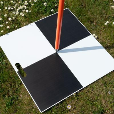
What Are Checkerboard Aerial Targets?
Checkerboard aerial targets are high-contrast markers, usually printed in a black-and-white checker pattern. When placed on the ground, they act as visual reference points that drones can easily detect during aerial surveys.
Unlike random ground markers, these targets are designed to stand out clearly in drone imagery, even from high altitudes. They are commonly used alongside ground control points (GCPs) and other survey tools to align aerial images with precise geographic coordinates.

Key Benefits of Checkerboard Aerial Targets
1. Enhanced Accuracy in Mapping
UAV mapping projects often require centimeter-level accuracy. By using checkerboard targets, surveyors can ensure that aerial images align correctly with control points,
minimizing distortions in the final map or 3D model.
2. Easy Detection in Drone Imagery
Thanks to their bold design, checkerboard aerial targets are highly visible against different backgrounds—whether placed on grass, soil, or pavement. This makes them easier for photogrammetry software to identify and use during processing.
3. Cost-Effective Survey Tool
Compared to advanced sensors or complex calibration equipment, checkerboard targets are inexpensive and reusable. They offer a budget-friendly way for professionals and small businesses to achieve high-quality results without overspending.
4. Versatility Across Industries
From construction and agriculture to mining and environmental monitoring, UAV mapping has a wide range of applications. Checkerboard aerial targets can be adapted for all these industries, providing reliable georeferencing wherever precise spatial data is required.
When to Use Checkerboard Aerial Targets
Construction Projects
Monitor progress, measure volumes, and track site development with improved accuracy.
Agriculture and Land Management
Enhance crop monitoring surveys and land analysis by ensuring data is aligned with real-world coordinates.
Research and Environmental Studies
From erosion mapping to habitat studies, checkerboard aerial targets help researchers collect reliable data.
Final Thoughts
Checkerboard aerial targets may appear simple, but their impact on UAV mapping accuracy is significant. They improve image alignment, enhance georeferencing, and provide a cost-effective solution for professionals across multiple industries. Whether you are a surveyor, construction manager, or researcher, adding these targets to your mapping workflow can help you achieve more reliable and precise results.
By combining UAV technology with practical tools like checkerboard targets and aerial mapping markers, drone-based surveying becomes both efficient and highly accurate.


Comments